
Everest Base Camp Trek Distance Guide: How Far You Walk Each Day
Ever wondered about the distances that shape the Everest Base Camp trek? Our page unravels the mystery, offering a step-by-step breakdown of the path to Everest’s doorstep. The Everest Base Camp trek stands as one of the world’s most iconic mountain adventures, leading through the heart of the Khumbu region to the foot of Mount Everest, the world’s highest peak. Along the way, trekkers are treated to stunning Himalayan vistas, traditional Sherpa villages, ancient monasteries, and the thrill of high-altitude trekking.
Clear autumn weather on the way to Dingboche
Many wonder how far each day covers on the Everest Base Camp trek or how long it takes to reach Everest Base Camp, and the questions about the most challenging sections along the Everest Base Camp trail are also common. This guide provides answers to these questions, helping plan a safe, enjoyable, and unforgettable journey to Everest. For insights into the trek’s difficulty at different stages, refer to the detailed guide on Everest Base Camp Trek Difficulty.
How Long is the Trek to Everest Base Camp?
The Lukla to Everest base camp trek distance is approximately 130 kilometers or 80 miles round trip. It is typically completed over 12 to 14 days depending on the itinerary and acclimatization schedule. Over the course of the trek, trekkers cover an average of 10 to 15 kilometers (6 to 9 miles) per day, depending on altitude, terrain, and acclimatization stops. Daily walking time typically ranges from 5 to 7 hours, with shorter distances but longer durations at higher elevations due to thinner air and frequent rest breaks. Where, the Everest Base Camp trek begins with a scenic flight from Kathmandu to Lukla, followed by a gradual walk-through classic Sherpa villages such as Phakding, Namche Bazaar, Tengboche, Dingboche, and Gorakshep before reaching Everest Base Camp.
Scenic trail to Somare with a clear view of Mount Everest and Lhotse
Throughout these destinations trekkers are treated to a visual feast of beautiful mountains, diverse vegetation and landscapes that shift with each step. Beyond physical adventure and natural beauty, the trek is also a cultural journey. The rich tapestry of Sherpa heritage, their unique traditions and the Himalayan way of life encourages a deeper connection between the locals and the trekkers. Reaching Everest Base Camp is the major highlight of the trek. Standing near the Khumbu Icefall and surrounded by towering Himalayan peaks is a powerful and unforgettable moment, making the journey truly once in a lifetime.
Everest Base Camp Trek Daily Distance Breakdown
Below is a tabulated outline of the distances between various locations along the Everest Base Camp trail, alongside the corresponding duration required to reach each destination:
| Day | Location | Distance (km) | Duration (hours) |
| 2 | Lukla – Phakding | 8 km | 3 to 4 hrs |
| 3 | Phakding – Namche Bazaar | 12.3 km | 5 to 6 hrs |
| 4 | Namche Bazaar (Acclimatization) | 7.2 km | 4 to 5 hrs |
| 5 | Namche Bazaar – Tengboche | 10.7 km | 5 to 6 hrs |
| 6 | Tengboche – Dingboche | 10.8 km | 5 to 6 hrs |
| 7 | Dingboche (Acclimatization) | 5.2 km | 4 to 5 hrs |
| 8 | Dingboche – Lobuche | 8.8 km | 5 to 6 hrs |
| 9 | Lobuche – Everest Base Camp – Gorakshep | 11.5 km | 8 to 9 hrs |
| 10 | Gorakshep – Kalapatthar – Pheriche | 17.2 km | 8 to 9 hrs |
| 11 | Pheriche – Namche Bazaar | 19.7 km | 7 to 8 hrs |
| 12 | Namche Bazaar – Lukla | 19.9 km | 8 to 9 hrs |
Day 2: Lukla to Phakding
The Everest base camp trek begins after a scenic flight from Kathmandu to Lukla landing at 2,860 m (9,383 ft). From Lukla, trekkers start their journey with a gentle downhill walk toward Chheplung, following the Dudh Koshi River to their left. Along the way, the captivating sight of Mount Kusum Kanguru (6,367m) unfolds at the Thado Koshigaon, further leading to Ghat.
Phakding village on the bank of Dudh Koshi river
Unlike the initial portion of the trail, the concluding stretch from Ghat presents a gentle ascent, culminating at an altitude of 2,610 m at Phakding. Covering 8 kilometers, the trek from Lukla to Phakding is an approximately three-hour expedition through various suspension bridges and picturesque sherpa villages.
- Trek Duration: 3 to 4 hours
- Trek Difficulty: Multiple small suspension bridges and minor rocky sections
- Difficulty Level: Easy
- Walking Distance: 8 kilometers (5 miles)
- Starting Altitude: Lukla – 2,860 m (9,383 ft)
- Altitude: Lukla – 2,860 m (9,383 feet)
- Ending Altitude: Phakding – 2,610 m (8,563 ft)
- Ascend: 548 m (1,798 ft)
- Descend: 779 m (2,556 ft)
Day 3: Phakding to Namche Bazaar
The trek from Phakding to Namche Bazaar covers 12.3 km (7.6 miles) and typically takes 5 to 6 hoursto complete. The trail to Namche Bazaar from Phakding follows the Dudh Koshi River through pine forests and small villages. Trekkers cross several suspension bridges, including the famous Hillary Bridge on this day.
Hillary Bridge
The day begins with trekkers eventually getting from Phakding to Monjo and passing through the charming little villages to get to Bengkar where the majestic Thamserku (6,608 m) looms into view. From Bengkar, the trail descends bringing trekkers to Jorsale while the trail identically fluctuates until the Hillary Bridge, named after Sir Edmund Hillary himself, also the last suspension bridge of the day. Today’s trek concludes after a steady 2.5 hour ascension to reach the bustling Sherpa town Namche Bazaar.
- Trek Duration: 5 to 6 hours
- Trek Difficulty: Steep 2-hour ascent with switchbacks from Jorsale to Namche; numerous suspension bridge crossings
- Difficulty Level: Moderate to Challenging
- Walking Distance: 3 kilometers (7.6 miles)
- Starting Altitude: Phakding – 2,610 m (8,563 ft)
- Altitude: Namche Bazaar – 3,440 m (11,286 ft)
- Ending Altitude: Namche Bazaar – 3,440 m (11,286 ft)
- Ascend: 1,521 m (4,990 ft)
- Descend: 737 m (2,418 ft)
Day 4: Namche Bazaar acclimatization
The acclimatization day helps trekkers adjust to the higher altitude. The hike starts with an ascension to Everest Viewpoint followed by the picturesque village of Syangboche, renowned among trekkers for its captivating views. Further, trekkers navigate a dominant flat trail to get to Hotel Everest View at 3,880 m (12,730 ft).
Hotel Everest View Adventure
From here, trekkers enjoy awe-inspiring vistas of peaks like Mount Everest (8,849m), Lhotse (8,516m), Nuptse (7,861m), and Ama Dablam (6,812m). Hotel Everest View is also considered one of the popular viewpoints in the Khumbu region. Ending with a descent from Hotel Everest View back to Namche Bazaar, the journey accumulates roughly 4 to 5 hours and covers 7.2 kilometers (4.5 miles) in total.
- Trek Duration: 4 to 5 hours
- Trek Difficulty: Steep climb to Everest View Hotel or Khumjung village
- Difficulty Level: Moderate
- Walking Distance: 2 kilometers (4.5 miles) round trip
- Starting Altitude: Namche Bazaar – 3,440 m (11,286 ft)
- Altitude: Everest View Hotel – 3,880 m (12,730 ft)
- Ending Altitude: Namche Bazaar – 3,440 m (11,286 ft)
- Ascend: 458 m (1,503 ft)
- Descend: 458 m (1,503 ft)
Day 5: Namche Bazaar to Tengboche
The trek from Namche Bazaar to Tengboche covers a distance of approximately 10.7 km (6.6 miles) and usually takes 5 to 6 hours to complete. The journey begins with a walk to Kenjoma along its well-made, mostly leveled but gently undulating trail.
Scenic trail to Tengboche with Ama Dablam on the horizon
From Kenjoma, the trail descends gradually to Phunke Tenga before climbing steadily through rhododendron and pine forests toward Tengboche. This uphill section is physically demanding but rewarding, with views of Kangtega (6,782 m) and Thamserku (6,608 m) appearing as the forest opens. It is upon arrival at Tengboche that trekkers are rewarded with an even more intimate perspective of the surrounding mountains, enhancing the surreal beauty of the landscape.
- Trek Duration: 5 to 6 hours
- Trek Difficulty: Steep 2-hour climb from Phunki Tenga to Tengboche; significant elevation gain despite descents
- Difficulty Level: Moderate
- Walking Distance: 7 kilometers (6.6 miles)
- Starting Altitude: Namche Bazaar – 3,440 m (11,286 ft)
- Altitude: Tengboche – 3,860 m (12,664 ft)
- Ending Altitude: Tengboche – 3,860 m (12,664 ft)
- Ascend: 1,055 m (3,461 ft)
- Descend: 612 m (2,008 ft)
Day 6: Tengboche to Dingboche
On the 6th day of the trek, the journey from Tengboche (3,860 m) to Dingboche (4,410 m) spans 10.7 kilometers and takes approximately six hours to complete. The trail beginning from Tengboche to Deboche is a gentle descent leading to Pangboche where trekkers are required to navigate a few suspension bridges. Pangboche a typical farm village, is renowned for cultivation in the area. Here, trekkers can also spot various massive mountains up-close.
Pangboche village
Following a mild ascent while crossing the tree line, the final stretch where trees are still visible, trekkers reach Somare. The final walk from Somare to Dingboche rewards trekkers with a closer view of mountains like Ama Dablam (6,812m), Nuptse (7,861m) and Lhotse (8,516m). Further at Dingboche, you can also see mountains like Peak 38 (7,590m), Island Peak, Mount Chiumo (6,890m), and Ama Lapcha.
- Trek Duration: 5 to 6 hours
- Trek Difficulty: Gradual but continuous uphill from Pangboche to Dingboche; increasing altitude effects
- Difficulty Level: Moderate
- Walking Distance:8 kilometers (6.7 miles)
- Starting Altitude: Tengboche – 3,860 m (12,664 ft)
- Altitude: Dingboche – 4,410 m (14,468 ft)
- Ending Altitude: Dingboche – 4,410 m (14,468 ft)
- Ascend: 950 m (3,117 ft)
- Descend: 486 m (1,594 ft)
Day 7: Dingboche Acclimatization
Dingboche serves a pivotal role as an acclimatization point following Namche Bazaar. The trek begins with a demanding uphill ascent to reach the summit of Nangkartshang Peak (5,083m). From the peak, trekkers can catch a panoramic view of mountains like Lhotse (8,516 m), Nuptse (7,861 m), Cho Oyu (8,188 m), Ama Dablam (6,812 m), Peak 38 (7,590 m), Makalu (8,481 m), Kusum Kanguru (6,367 m), and Baruntse (7,163 m) gracefully surrounding the peak.
Nangkartsang Peak hike
The acclimatization journey concludes as trekkers make their way back to Dingboche after having covered a total distance of 5.2 kilometers, taking 4 to 5 hours to complete.
- Trek Duration: 4 to 5 hours
- Trek Difficulty: Steep climb to Nangkartshang Peak or Chhukung; thin air makes breathing labored
- Difficulty Level: Moderate to Challenging
- Walking Distance:2 kilometers (3.2 miles) round trip
- Starting Altitude: Dingboche – 4,410 m (14,468 ft)
- Altitude: Nangkartshang Peak – 5,083 m (16,677 ft) or Chhukung – 4,730 m (15,518 ft)
- Ending Altitude: Dingboche – 4,410 m (14,468 ft)
- Ascend: 758 m (2,487 ft)
- Descend: 758 m (2,487 ft)
Day 8: Dingboche to Lobuche
On the 8th day of Everest Base Camp Trek, trekkers head toward Lobuche from Dingboche covering approximately 8.8 kilometers (5.5 miles) in about 5 to 6 hours, depending on pace and altitude conditions. The path from Dingboche to Thukla involves a gentle ascent, offering trekkers glimpses of several mountains including the flanks of Cho La, Taboche (6,495 m), and Cholatse (6,440m).
Ascending through the Khumbu Khola valley, the trail gradually leads to Thukla and continues upward until Thukla Pass. Beyond the Thukla pass, the terrain transforms into a more rugged and barren landscape as trekkers approach Lobuche.
Lobuche Village
Lobuche further welcomes trekkers with captivating views of various mountains like Nuptse (7,861m) Changri (6,027m), Pumori (7,161m), and Lho La (6,006m).
- Trek Duration: 5 to 6 hours
- Trek Difficulty: Steep memorial hill climb from Dughla; walking on rocky moraine; significant altitude effects
- Difficulty Level: Challenging
- Walking Distance:8 kilometers (5.5 miles)
- Starting Altitude: Dingboche – 4,410 m (14,468 feet)
- Altitude: Lobuche – 4,940 m (16,207 ft)
- Ending Altitude: Lobuche – 4,940 m (16,207 ft)
- Ascend: 873 m (2,864 ft)
- Descend: 326 m (1,070 ft)
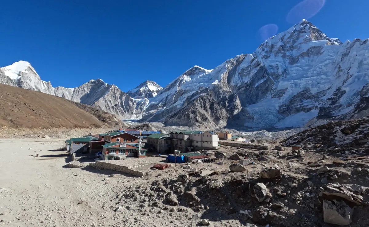
Day 9: Lobuche to Everest Base Camp and back to Gorakshep
On the 9th day, trekkers hike from Lobuche toward Gorakshep at 5,190 m, following a trail that begins with a gentle ascent and later becomes rocky and uneven. From Gorakshep, the route continues toward Everest Base Camp across an undulating glacial path with frequent short ascents and descents.
Everest Base Camp
The round trip from Lobuche to Everest Base Camp and back to Gorakshep covers approximately 11.5 kilometers (7.1 miles) and typically takes 8 to 9 hours in total. Upon reaching Everest Base Camp, trekkers are rewarded with close-up views of towering Himalayan peaks and the dramatic Khumbu Icefall.
- Trek Duration: 8 to 9 hours
- Trek Difficulty: Rocky moraine walking; significant altitude at EBC (5,364m); long day with high elevation gain
- Difficulty Level: Challenging to Very Challenging
- Walking Distance:5 kilometers (7.1 miles)
- Starting Altitude: Lobuche – 4,940 m (16,207 ft)
- Altitude: Everest Base Camp – 5,364 m (17,598 ft)
- Ending Altitude: Gorakshep – 5,160 m (16,929 ft)
- Ascend: 730 m (2,395 ft)
- Descend: 430 m (1,411 ft)
Day 10: Hike to Kala Pathhar and descent to Pheriche
The day begins with an early morning ascent to Kala Pathhar (5,555 m) from Gorakshep, following a steep and challenging uphill trail. Upon reaching Kala Pathhar trekkers are rewarded with breathtaking 360-degree views of prominent mountains like Pumori, Lingtren (6,749 m), Lho La, Mount Everest (8,849 m), Lhotse (8,516m), Nuptse (7,861 m), Ama Dablam, Kangtega (6,782 m), Thamserku, Taboche, and Changri.
A view of Khumbu Glacier and Himalayas from Kala Patthar
Descending back to Pheriche, trekkers retrace their steps through the same route used at the time of ascension, passing through Lobuche and Thukla Pass. It is after Thukla Pass that trekkers diverge towards Pheriche, concluding their trek for the day. The total walking distance for the day is approximately 17.2 kilometers (10.7 miles), and the trek typically takes 8 to 9 hours to complete due to the high altitude and long descent.
- Trek Duration: 8 to 9 hours
- Trek Difficulty: Pre-dawn climb to Kala Patthar in extreme altitude; very long day with significant descent
- Difficulty Level: Very Challenging
- Walking Distance:2 kilometers (10.7 miles)
- Starting Altitude: Gorakshep – 5,160 m (16,929 ft)
- Altitude: Kala Patthar – 5,545 m (18,192 ft)
- Ending Altitude: Pheriche – 4,371 m (14,340 ft)
- Ascend: 670 m (2,198 ft)
- Descend: 1,609 m (5,279 ft)
Day 11: Pheriche to Namche Bazaar
The descent from Pheriche to Namche Bazaar is one of the longest and most rewarding days of the Everest base camp trek journey, encompassing a total distance of roughly 19.7 kilometers to be covered in approximately 7 to 8 hours.
Descend Pheriche, Namche from Everest Base Camp
Trekkers retrace their steps through familiar landmarks with a beginning descent from Somare and gradually progress through Pangboche, Deboche, and Tengboche. The trail continues downhill to Phunke Tenga, the lowest point of the day. After crossing the river at Phunke Tenga, trekkers face a steady uphill climb to Kenjoma before finishing with a relatively flat traverse into the vibrant Sherpa town of Namche Bazaar.
- Trek Duration: 7 to 8 hours
- Trek Difficulty: Long descent followed by gradual ascent; forest trails and stone steps
- Difficulty Level: Moderate
- Walking Distance: 7 kilometers (12.2 miles)
- Starting Altitude: Pheriche – 4,371 m (14,340 ft)
- Altitude: Namche Bazaar – 3,440 m (11,286 ft)
- Ending Altitude: Namche Bazaar – 3,440 m (11,286 ft)
- Ascend: 617 m (2,024 ft)
- Descend: 1,404 m (4,606 ft)
Day 12: Namche Bazaar to Lukla
The trek from Namche Bazaar to Lukla marks the final day of the Everest Base Camp trek. It covers approximately 19.9 km (12.4 miles) in 7 to 9 hours. Leaving Namche Bazaar, trekkers descend steeply toward the Dudh Koshi River, crossing the iconic Hillary Suspension Bridge before continuing through Jorsale, Monjo, Phakding, and Chheplung.
Clear view of Lukla Airport
The route retraces the same scenic path taken during the ascent, offering a nostalgic conclusion to the adventure. Upon reaching Chheplung trekkers make a gentle ascent for a few meters to arrive at Lukla, the very destination where the Everest Base Camp trek officially comes to an end.
- Trek Duration: 7 to 9 hours
- Trek Difficulty: Long day with mixed ascents and descents; stone steps and suspension bridges
- Difficulty Level: Moderate
- Walking Distance: 9 kilometers (12.4 miles)
- Starting Altitude: Namche Bazaar – 3,440 m (11,286 ft)
- Altitude: Namche Bazaar – 3,440 m (11,286 ft)
- Ending Altitude: Lukla – 2,860 m (9,383 ft)
- Ascend: 1,433 m (4,701 ft)
- Descend: 2,007 m (6,585 ft)
Why the Everest Base Camp Trek Feels Longer Than the Distance
Although the daily distances on the Everest Base Camp trek may seem manageable, trekking at high altitude makes the journey much more challenging. As elevation increases, oxygen levels decrease, slowing walking speed and requiring frequent rest breaks. Steep ascents, rocky paths, and suspension bridges add to the physical effort, making even short sections feel longer. Weather and temperature also affect the trek. Cold mornings, strong winds, and changing conditions can slow progress, especially in higher sections like Lobuche, Gorakshep, and Kala Patthar.
Combined with backpack weight and long daily walking hours, these factors make the trek feel longer than the actual 130 kilometers (80 miles), while also creating an unforgettable and rewarding experience.
Everest Base Camp Trek Distance Compared to Other Treks in Nepal
The Everest Base Camp trek, at approximately 130 km (80 miles) round trip over 12 to 14 days, is one of Nepal’s most iconic treks. While its distance is shorter than some other Himalayan treks, the high altitude and challenging terrain make it equally demanding.
- Annapurna Base Camp Trek: ~110–120 km (68–75 miles), 10 to 12 days
- Langtang Valley Trek: ~65–75 km (40–47 miles), 7 to 9 days
- Manaslu Circuit Trek: ~170 km (106 miles), 14 to 18 days
- Annapurna Circuit Trek: ~160–230 km (99–143 miles), 14 to 21 days
- Gokyo Lakes Trek: ~134 km (83 miles), 12 to 14 days
- Kanchenjunga Base Camp Trek: ~220 km (137 miles), 20 to 22 days
- Upper Mustang Trek: ~150 km (93 miles), 12 to 14 days
Although the Everest Base Camp trek is moderate in distance compared to some of these longer treks, its high altitude, unpredictable weather, and steep ascents make it feel more challenging, offering trekkers an unforgettable Himalayan adventure.


